What is this Boundary Review?
Setting the Context
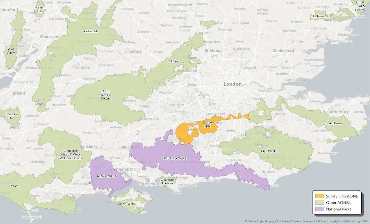
Areas of Outstanding Natural Beauty (AONBs) represent some of England’s most outstanding and treasured landscapes, whose special qualities are so precious that it is safeguarded in the national interest. AONBs are equivalent to National Parks in terms of the national importance of their natural beauty.
A key difference between the two types of designation is that National Parks also have a second statutory purpose to ‘promote understanding and enjoyment of {their} special qualities by the public’ although this is something that the Surrey Hills AONB team also strive to do.
Surrey Hills
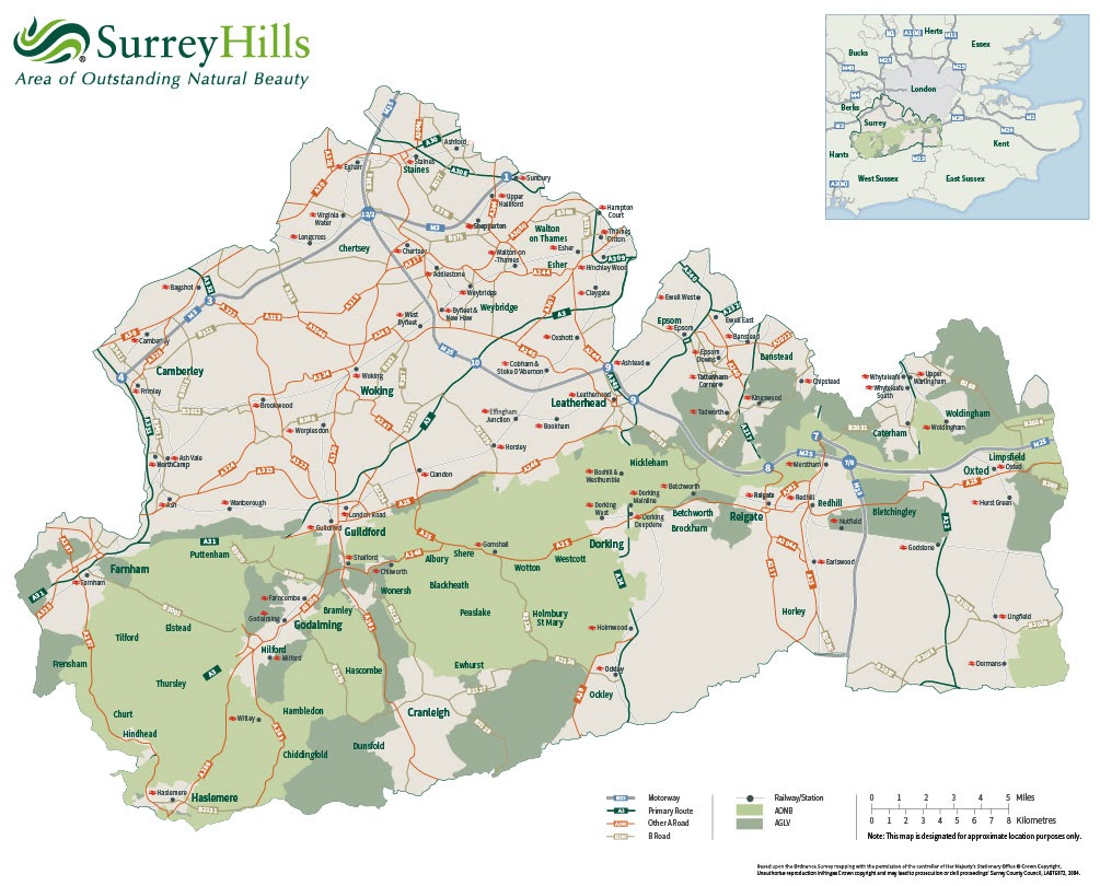
The Surrey Hills AONB covers a 422 km² stretch of North Downs and Greensand Ridge landscapes, including the ridge and south facing scarp of the chalk downlands and the greensand hills that fringe the Low Weald to the south of the North Downs.
This is one of England’s most accessible protected landscapes which is on the doorstep of a string of major towns, including Aldershot, Guildford, Godalming, Dorking, Leatherhead, Reigate, Caterham and Oxsted.
Why is the boundary of the Surrey Hills AONB under review?
Natural England is the Government’s adviser on the natural environment and has powers under the Countryside and Rights of Way Act 2000 to consider which areas meet the statutory criterion for designation as an AONB, and then to designate such areas, if it is desirable to do so.
The Surrey Hills AONB boundary has not been reviewed since its original designation in 1958 and there have been repeated calls by local campaigners to reconsider the boundary. Some areas of countryside outside but adjacent to the AONB boundary are designated as Areas of Great Landscape Value (AGLV) by local authorities in recognition of their value at a county level. Following a series of landscape evaluation studies and a formal request by the Surrey Hills AONB Board, Natural England has now started the AONB boundary review process.
In June 2021, a written ministerial statement by Secretary of State, George Eustice (Defra) announced that Natural England ‘will be taking forward the government’s commitment to designate additional protected landscapes and is currently considering the designation of four new areas’. This includes a possible extension to the Surrey Hills AONB.
Full details of Natural England’s subsequent announcement can be seen via the link below:
How will the boundary review process work?
Natural England has appointed consultants to undertake the assessments required for the boundary review. There will be a strong emphasis on collaboration and engagement so that anybody with an interest in the Surrey Hills landscape has an opportunity to contribute to the process.
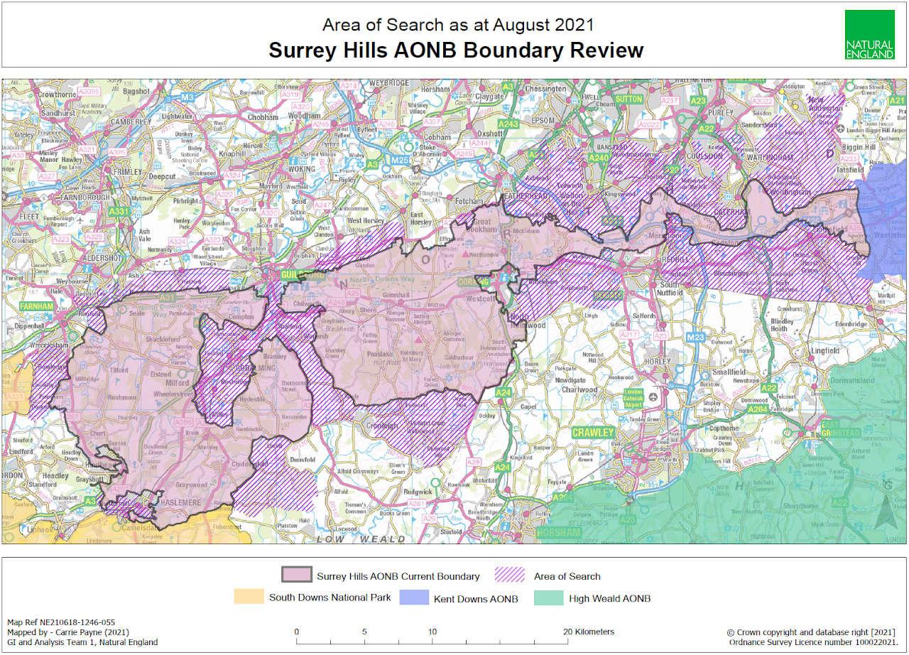
The Area of Search shown in the map forms the starting point for the boundary review work. Please note that the Area of Search is not a proposed AONB boundary and that it is likely only a proportion of the area will qualify for AONB designation.
Boundary Review Timetable
November 2021 - January 2022
Call for evidence - The project begins with a ‘call for evidence’ to gather a range of data and information in a structured way which addresses the specific technical requirements of the formal assessment process. There is a strong emphasis on collaboration and 'citizen science', with opportunities for stakeholders including members of the public to participate via an online engagement platform and a digital app, as well as via workshops. Please go to our Share your Knowledge page to find out more about how to participate in providing evidence to support the assessments.
A structured framework for the assessment - The AONB boundary review follows a formal process which tests the application of the statutory ‘natural beauty’ criterion for AONB designation in a consistent, objective way. The Area of Search is divided into a number of Evaluation Areas which form an initial framework to gather, collate and assess evidence on which judgements are made. The Evaluation Areas are defined to exclude adjacent settlements, although in some instances they include built up areas. Please note we are not seeking evidence on significant built-up areas. Where Evaluations Areas abut open countryside their boundaries are 'fuzzy'. We request you provide evidence for land within the Evaluation Areas, however we will consider evidence beyond the Evaluation Area where it is contiguous or where there is a strong case for consideration. Please see our Story Map for further information on the Evaluation Areas.
The box below shows the set of factors that Natural England has developed for assessing landscapes for national designation. These will form the basis for assessing natural beauty.
Factors related to natural beauty
Landscape quality - This is a measure of the current physical state or condition of the landscape and its features.
Scenic quality - The extent to which the landscape appeals to the senses (primarily, but not only, the visual senses).
Relative wildness - The degree to which relatively wild character can be perceived in the landscape and makes a particular contribution to sense of place.
Relative tranquillity - The degree to which relative tranquillity can be perceived in the landscape.
Natural heritage features - The influence of natural heritage on the perception of the natural beauty of the area. Natural heritage includes flora, fauna, geological and physiographical features.
Cultural heritage - The influence of cultural heritage on the perception of natural beauty of the area and the degree to which associations with particular traditions, people, artists, writers or events in history contribute to such perception.
February - April 2022
Evaluation of Natural Beauty – This stage will begin after the initial engagement activities have been completed so that all the relevant information provided is taken into account. This involves a combination of desk based work and detailed field survey. The landscape within each Evaluation Area is assessed in turn against the factors which contribute to natural beauty. Whilst in the field, further information is gathered to cover the more perceptual aspects of landscape including scenic quality, condition and tranquillity, and the information that has been collated so far, is tested and verified. The process typically highlights key issues which require particular scrutiny and further work, including transitions in landscape and scenic quality, areas where natural beauty is present but fragmented and the influence of detracting features and/or settlements on levels of natural beauty.
May - June 2022
Identify Candidate Areas – The next step is to identify and map Candidate Areas for AONB designation. These are areas that have been assessed as having outstanding natural beauty. Land can only be included where there is sufficient weight of evidence that the natural beauty criterion is met. Note that Candidate Areas must not be taken to be an indication of a potential new boundary which will be defined at a later date (see Further Stages below).
The following stages happen after engagement activities have stopped, but don’t worry because there is another opportunity to be engaged in the process during formal consultation – see below.
Desirability Assessment – An area of land that satisfies the natural beauty criterion is capable of being included in an AONB. A judgement must be made as to whether a Candidate Area should become part of the Surrey Hills AONB in order to achieve the AONB’s statutory purpose, which is to conserve and enhance natural beauty. To establish whether it is desirable to designate an area as an AONB, the following five questions are asked:
Is there an area which satisfies AONB technical criterion?
Is the area of such significance that the AONB purpose should apply to it?
What are the issues affecting the area’s special qualities?
Can the AONB statutory purpose be best pursued through the management mechanisms, powers and duties which comes with AONB designation?
Are there other relevant factors which tend to suggest whether or not it is desirable to designate the area?
It should be noted however, that 'desirability' does not automatically infer designation: it is for Natural England to exercise its judgment on this in later stages.
Final Reports – The case for extending the AONB boundary will be presented in detailed reports, which bring together all the evaluation work and sets out the evidence in accordance with the legislation. For example, the reports will provide detailed information for each of the factors which contribute to natural beauty in each Evaluation Area, in order to identify Candidate Areas and assess the desirability of designating qualifying areas as extensions to Surrey Hills AONB. Issues which will need to be addressed when defining a boundary, at a later stage, will also be highlighted.
Future stages
Having considered these reports and relevant evidence, it will be for Natural England to decide whether or not, a particular area is of such national significance that it should be designated as an AONB and managed to achieve the statutory purpose.
Reaching such a decision will involve two key stages, details of which can be expanded and collapsed by clicking on the headings below.
There will be an opportunity for you to comment on any future proposed AONB extension, including the boundary, during the Statutory Consultation.
Identifying a suitable boundary
If Natural England decides to proceed then a suitable boundary will be drawn. Natural England has developed a suite of principles for defining boundaries and these will be applied, including those listed below, to apply in boundary identification:
Transition areas: Natural beauty often changes gradually over a sweep of country rather than suddenly from one field to another. In these ‘areas of transition’, the boundary should be drawn towards the high quality end of the transition in a manner that includes areas of high quality land and excludes areas of lesser quality.
Types of boundary: Wherever possible, a clear physical feature should be chosen.
Other administrative boundaries: Administrative boundaries (such as county or parish boundaries) are often unsuitable because they are hard to see on the ground or do not correspond with the area of high natural beauty. Similarly, land ownership is not itself a reason for including or excluding land from designation – there will often be instances where part of a landholding sits within the designated area and part sits outside.
Inclusion of settlements: Towns and villages at the edge should only be included if they are within and part of a sweep of qualifying countryside.
Splitting of settlements: Towns or villages should not normally be cut in two by an AONB boundary where it can be avoided.
Incongruous development: Unsightly development on the edge of an AONB should generally be excluded unless it is of a temporary or transient nature.
Proposed Developments: Land at the edge of a proposed designation that is identified for development in development plans, or has existing planning permission should normally be excluded. Land should not be included merely to seek to protect it from specific development proposals.
Features of interest: Areas and features of wildlife, geological, geomorphological, historic, cultural or architectural value should be included where practicable.
Consultation on the Final Recommendations and Formal Procedures
Natural England is required by the Countryside and Rights of Way Act, to consult the County and District Councils affected by the proposed boundary variations. In addition this consultation will be extended to allow everyone with an interest in the proposed extensions to comment on the proposals including the detailed evaluation and evidence used to support designation, identification of qualifying areas, desirability to designate and the detailed boundary. At the end of the consultation we will analyse all the responses and review the proposals and if necessary, amend them to take account of any further relevant evidence provided.
If, as a result of the statutory and public consultation, additional land needs to be included within the proposed boundary variation, an additional statutory consultation will be required.
If no fundamental objections arise which cannot be overcome, and assuming no additional land needs to be included as a result of the consultation, the next stage will be to draw up a draft Order and to publish Notice of the Order in the London Gazette and other papers as required by Section 83(2) of the CRoW Act. The Notice period allows anyone who wishes to do so to make representations to Natural England, objecting to, supportive of, or proposing amendments to the Order, and stating the grounds on which they are made.
Following the Notice period, a further period of response analysis will be required and any further consequent changes made to the draft legal Order. Natural England Board approval will then be sought to allow the Order to be ‘made’ and submitted to the Secretary of State for confirmation. If there are any unresolved objections, these will be submitted to the Secretary of State with the legal Order.
The Secretary of State has discretion to call a Public Inquiry to consider any such objections before deciding whether or not to confirm the Order. The Secretary of State may or may not confirm the Order, with or without amendment and this final decision is not required to be made to any specific timescale.